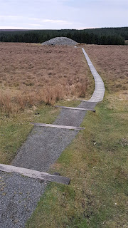
These are a pair of 5,000 year old prehistoric stone mounds which were once the 'community centre' of a local settlement, but now stand alone in very lonely countryside, with only a minor road and some plantations for company. I had a look at them on 11th April last year.
This location map shows the Cairns in the centre. (Click on all these maps to get the detail)
There aren't many roads across Caithness, because the interior is mostly rough grazing or peat bog, with some modern plantations. The Cairns lie on one of the few cross-country roads, but it's not a main road and really only links Lybster with Watten to the north, neither of them places of much consequence, although Lybster (you pronounce it LIBE-STER) has a good harbour and was once an important fishing port. But even as late as 1900, there were no good roads in and out of Lybster, and so it acquired its own light railway to Wick, off to the north-east, which operated from 1903 to 1944, by which time roads had improved and road transport had taken the railway's business.
I was in fact keen to see one of the few remaining earthworks of this short-lived line, an embankment at the south end of the minor road, close to Lybster, and just north of its junction with the A99. The line of the old railway was marked on this map:
I took this shot from just north of West Clyth Farm:
You can see the long horizontal line of the old railway embankment in the middle distance. It's hard to see how the line could ever have covered its running costs, never mind repay the costs of construction. No doubt the war effort in 1944 needed its scarcely-used iron rails for shells and tanks, and that was that.
I drove on, not intending to stop at the Cairns, but when they came into view on my left I just had to park Fiona and take a closer look.
The two Cairns looked very mysterious in the moody late afternoon light. The smaller one was round with one entrance; the larger one long with two entrances. I had a look at the round one first. They were set well back from the road, but there were proper boarded walkways and information panels.
The lower of the two maps just above shows a scattering of 'hut circles' nearby. So the Cairns were in the middle of a farming community.
You can't fault the presentation. I was however more than slightly worried about the reference to the French governess of the 1880s getting stuck inside the mound and having to be rescued through a hole at the top!
I approached the low and rather small stone entrance. Hmm. I'd have to crawl inside. And it was very dim.
This needed the right clothes and a good torch. Also a certain amount of nerve (what if I too got stuck?). No, this wasn't to be attempted just before sunset on a cold April afternoon, with nobody on hand if I got into difficulties. It had the atmosphere of a tomb.
Maybe the larger mound would be an easier proposition? I trekked over to it.
This was the nearer entrance. Well, it might be described as more 'palatial', but I'd still have to bend low or crawl to enter, and it was hardly less dim inside as the round mound. Passing this entrance up, I went on to the other.
Gosh, this was a very big mound! It would need an awful lot of stones to build it. But then that would give the backbreaking labour of clearing the land around of stones a useful secondary purpose. Here was the other entrance, even less inviting than the first.
I felt a bit of a wimp, not even trying to get inside. But really, with the light fading it wouldn't have been wise. And all this time - I'd been there half and hour or so - only one other car had driven past, and I was a long way from the road. No hope of assistance.
So I came away.
Oh...the information panel admitted that the exterior appearance of these Cairns was a modern reconstruction, albeit based on evidence. Well, I thought the mounds looked a bit too neat and tidy for 5,000 year old structures! So this was the equivalent of repairing Stonehenge so that all the fallen stones were now upright, and all the missing ones were replaced with fibreglass replicas. And calling it authentic.
Never mind. The overall effect was still mysterious and atmospheric, and the bleak setting perfectly evocative.
It was getting chilly. I was glad to get into Fiona again and drive on. I didn't go back to Dunnet Bay via Thurso. I went across country via Watten and Castletown. Passing Loch Watten, the red sun shone balefully onto the metallic-seeming water.
But it was bright and cheerful in the caravan. It was salmon that night:
I'd lunched very well in Wick at a French restaurant, but had plenty of appetite after my archaeological investigations!


