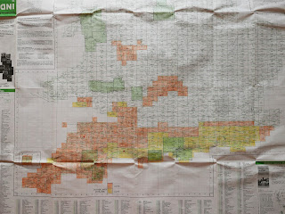
You buy coverage in High-Definition 10km x 10km squares at £1.49 or £1.99 per square, through the OS's MapFinder phone app. I've been getting them in batches, £10 or £20 a time, whenever I have some spare funds. The yellow squares on my master map represent squares purchased last year, in 2015. Squares purchased this year, 2016, are coloured orange. As you can see, I've gone all out to ensure that the entire South Coast and the South West of England has this large-scale continuous coverage, which is excellent for detailed exploration by foot. But there are also some other areas covered, such as most of the Cotswolds, some of the Welsh Border, Gower, and little bits of Scotland, Orkney and Shetland.
I will of course be buying more of these Explorer map squares, but the essential coverage is now there, and I will think carefully about every future addition. It's been quite an investment. I've bought 423 map squares in the last twelve months at a cost of £786. In the twelve months to come, I shall need money like that for things such as dental treatment, and to help cover the cost of my Scottish holiday, pencilled in for May or June 2017. So my map square purchases are henceforth going to reduce to a trickle!
I do of course have the entire country digitally covered in High Definition by the next scale down, the OS's 1:50,000 Landranger map. That's installed on both phone and laptop. It's completely adequate for touring and exploring any area, unless you want the really fine detail that the 1:25,000 Explorer map provides. And there is as well my vast collection of paper maps at a variety of scales, going back to the early 1900s. I always take some of those on holiday, to find the location of things that were once there, but are no more.
When young, at age ten say, I yearned to have a seamless large-scale map on a handy gadget I could easily carry around. The 2016 reality on a smartphone is a dream come true. Gosh, think what I can now do! I can look at Penzance in the far south-west, and Folkestone in the far south-east...
...I can contemplate Rhossili on Gower, and the Rollright Stones on the Cotswolds...
...and imagine a day on Lundy in the Bristol Channel, or an autumn tramp through the New Forest...
In my opinion, these are beautiful maps - and actually better to view on a back-lit phone screen than in traditional printed paper form. The OS will also update them automatically, whenever a new paper version is published.
If you detect a certain 'treasure island map' mentality behind my practical enthusiasm, I dare say you are quite right. I have been romanticising over maps and atlases all my life. Maps urge me on to see places for myself. And of course, photograph what I find. The entire country is stuffed with interesting things to seek out, and these large-scale maps are the key. My next holiday, two weeks ahead, is mainly devoted to the events of the Appledore Book Festival, but I have a few days free to whizz off in Fiona. I intend to make ancient standing stones and holy wells my theme on these outings. And to find them, my Explorer mapping will be essential.


