On 19th March - not quite six weeks ago - I wrote a post titled A fruitful conversation with BT, in which I related how, with no BT Broadband service at the time because of a flood problem where the green cabinet was, I'd had to resort to 4G Mobile Internet for all my Internet needs. I was using it so much that I was in grave danger of exceeding my monthly 12GB data allowance, for which I was paying £15 per month.
The BT chap I spoke to in Swansea gave me a cracking 'emergency' deal: upgrade to 100GB for just £20 per month, with the first two months of this at no extra charge, to last until my SIM-only contract ended naturally on 9th July. After then, I'd need to choose another data plan, from whatever was available at the time.
I accepted. It was very reassuring to have 100GB at my disposal at no immediate extra cost. For two weeks I was very free with Mobile Internet, though making scarcely a dent in this monster allowance.
Then BT repaired the damage, and restored the Broadband service. Since then that 100GB allowance has not been needed. In fact it's ridiculously too big for my modest needs. I'd discovered that 20-30GB would be perfectly adequate, even if I turned into a regular watcher of streamed TV (a most unlikely thing). And the end of the contract was looming. July was getting closer. I didn't want to face an automatic price hike based on 100GB. It was time to return to a much smaller allowance, and a sensible ongoing monthly payment.
I saw that BT were currently offering 20GB for £15, so I decided to phone them and ask for that instead. It would of course mean a fresh SIM-only contract with them lasting 12 months. But I was happy with BT Mobile. I was also making this change before the end of my current contract - actually nine weeks before - and I wondered whether there would be a penalty. But I reckoned BT would allow it without demur.
So I made that call, and got that deal. It's been confirmed in an email.
I was right in thinking that the new data plan wouldn't come into force at once. There's a delay. The old plan remains alive until the date of my next BT bill, which is 27th May 2020. So if I'd left doing this until after then, I'd have been stuck with an extra charge for having 100GB until 27th June. And if I'd done nothing until after 27th June, I'd be stuck with that extra charge for 100GB until 27th July. BT might have got nearly two months of extra charge out of me. But not now.
The new SIM-only data deal expires on 27th May 2021. Nice to have that settled for over a year ahead. As it stands I will be paying £20 for one more month, then only £15. The £5 saved will soften the effect of an £8 rise in my electricity/gas bill, which comes into force at the same time. (As one bill goes up, I look for a way to reduce another)
I've benefited from the price war going on between the mobile phone service providers. It means keen deals. BT is never the cheapest, but (a) it uses EE's excellent network, and (b) I do get a £5 a month discount for having BT Broadband as well.
But how data prices have come down! Three months ago I was paying BT £15 per month for 12GB. Now the same money will buy 20GB. That's 66% more data. And you can be sure that BT still make a good profit.
These deals are improving month by month. I wonder what £15 will buy in 2021? Or putting it another way, will 20GB cost as little as a tenner? Or even less?
Wednesday 29 April 2020
A foxy tale
Rain, rain, rain. Such a sudden change from two weeks of fine (and rather warm) weather! It's presently cool, damp and murky outside.
But three days ago I did a four-miler on the South Downs, and saw a fine sunset. And some other things. This post is about all that.
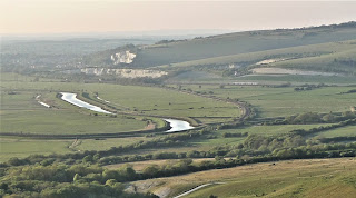
I'd driven to Itford, a tiny place about ten miles away on the A26 between Beddingham and Newhaven, in the past not much more than a farm. But now part of that old farm has been taken over by the Youth Hostel Association, because the South Downs Way - a famous long-distance footpath - runs through here. The land hereabouts is part of the South Downs National Park.
The SDW comes down from the hills to the west, passes through tiny Southease village, goes out across the flood plain of the River Ouse, crosses the river itself by a swing bridge (although it swings no longer, being fixed nowadays), runs through Southease station (which has a train in each direction every hour, right up to late evening, although it's really quite a lonely station), then, passing near the YHA at Itford, crosses the A26 by a modern footbridge and heads eastwards up Itford Hill. Once up there, the SDW continues to Alfriston in the Cuckmere Valley, and ends at the brink of the high chalk cliffs of Beachy Head, where walkers are advised to stop. Just east of Itford Hill are two 'dew ponds', marked on the Ordnance Survey map as Red Lion Pond and White Lion Pond. I intended to visit those ponds on foot as my daily exercise.
Here are two maps. As ever, click on them to see the detail better.


But three days ago I did a four-miler on the South Downs, and saw a fine sunset. And some other things. This post is about all that.
I'd driven to Itford, a tiny place about ten miles away on the A26 between Beddingham and Newhaven, in the past not much more than a farm. But now part of that old farm has been taken over by the Youth Hostel Association, because the South Downs Way - a famous long-distance footpath - runs through here. The land hereabouts is part of the South Downs National Park.
The SDW comes down from the hills to the west, passes through tiny Southease village, goes out across the flood plain of the River Ouse, crosses the river itself by a swing bridge (although it swings no longer, being fixed nowadays), runs through Southease station (which has a train in each direction every hour, right up to late evening, although it's really quite a lonely station), then, passing near the YHA at Itford, crosses the A26 by a modern footbridge and heads eastwards up Itford Hill. Once up there, the SDW continues to Alfriston in the Cuckmere Valley, and ends at the brink of the high chalk cliffs of Beachy Head, where walkers are advised to stop. Just east of Itford Hill are two 'dew ponds', marked on the Ordnance Survey map as Red Lion Pond and White Lion Pond. I intended to visit those ponds on foot as my daily exercise.
Here are two maps. As ever, click on them to see the detail better.


There were three cars at Itford. One was parked up by the YHA, and presumably belonged to the skeleton staff left to look after the place while it was temporarily closed in the lockdown. I've never belonged to the YHA, but I thought their hostel at Treyarnon Bay in Cornwall - open to the public for teas - was pretty good for facilities, and this one at Itford seemed just the same. They had a large, decent-looking café, also open to the public, which must be very busy in normal times.


Another car was parked close to some accommodation pods. I couldn't decide whether they were part of the YHA set-up, or just holiday homes, or even ordinary residences, albeit somewhat bijou. An older man occupied one of them - I saw him later on.

And there was a third car. More on the owner later!
Having donned the Alt-Bergs, I set forth. The first objective, only two hundred yards away, was the fine footbridge over the A26.

The bridge was installed in 2006, and in ordinary times takes a small army of walkers and mountain-bikers away over the busy road, which leads down to the industrial and passenger-ferry quayside at Newhaven.

Previously they'd all had to take their chances crossing on the level, a dangerous business. Mind you, it was a very quiet road indeed just now!


It was just gone 6.20pm. My next objective was the clump of windswept trees on the top of Itford Hill, up ahead in the next shot.

The SDW would first swing off to the right, then swing back to tackle a longish but not too steep slope all the way to the top of the hill. After that, the going would be more or less level. At first it was a stony chalk track, pretty rough, the sort that makes you thankful that you put stout walking boots on, and thick socks to cushion the feet. But soon it was possible to walk on short grass to one side. Then, close to the dogleg, it all became short grass, so smooth that you could have walked on it in slippers.
Every now and then, I paused to look around and take a picture.


Really wide views, and very little haze. It was mild, but cool enough to want a jacket of some kind. There was enough of a breeze to slightly ruffle my hair.

To the south, in the middle distance, lay the riverside village of Piddinghoe. That's where Ouse Cottage was, the investment property I bought jointly with M--- in 2007, my only home for the first half of 2009, and on my hands for four years until finally sold in August 2011, at a loss to me of £200,000. I will never recover financially - nor emotionally - from that ruinous adventure. I knew it at the time. This was me, back on 29th August 2011, having a last tour of the Cottage before handing over the keys. Close to tears, I think, and for a cluster of reasons.

I look a thought more careworn now, in 2020. Or is it just the natural ageing process? But I can still smile! And I still think that Piddinghoe is a very attractive village, with a great sense of community. A pity I was unable to make a go at living there.

Same direction, but off to the left: Newhaven - and the sea.

Well, this was the way ahead. Uphill!

A cyclist, the second one who had recently passed me, was already near the top, though clearly finding the slope rather taxing. Perhaps he was stuck in the wrong gear. I encountered nobody else while up on the Downs. Apart from the sheep, I had all this wide-open space to myself.
It seemed to be a gentle slope up to those trees, but it entailed a surprising amount of effort. I wasn't sorry to take a breather or two. But then, as I reached the trees, it suddenly got much easier. I went over to that little wood, or copse, or shaw, whatever the proper term is. The trees on the edge of it were very windswept, which reveals how exposed these hills are to winter winds.

Inside the wood, though, it was sheltered and serene. Uncannily so. A different, almost mystical world, with strange tree shapes, dancing shadows, and an atmosphere of its own.


I had conjectured that the sheep would enter this wood when night fell, but there were no tell-tale wisps of wool on the tree trunks. Perhaps they felt in awe of the place. Groves of trees like this often do repel animals and birds, or at least hush them, so that the interior of the wood is deathly soundless and other-worldly. The classic example is Wistmans Wood on Dartmoor, which I visited in 2017, and which is covered in my post Wistmans Wood on 18th November 2017. But this wood lacked the rocks, thick moss and rather unwholesome lichen I saw there. This was more open, with glimpses of the outside world, and if in the right mood one might think to spend the night here, which one definitely wouldn't want to do in Wistmans Wood.
Emerging, I got the view northwards to Mount Caburn.


I was using the Leica's 'digital zoom' for these long-distance shoots, which merely magnified the shorter telephoto effect obtained optically. So the resolution isn't great. But you can make out the ancient ditch surrounding the summit of Mount Caburn. Walking slightly further on, and looking more to the north-west, you could make out the River Ouse, and a train from Eastbourne on its way to nearby Lewes.


In the opposite direction, southward to the sea, was a better view of Newhaven.


That prominent building with twin chimneys is the incinerator that blighted local property values from 2008 - Ouse Cottage included. It hadn't shown up in the 2007 searches made by my solicitor, nor in the careful searches we made personally at the Lewes DC offices. I got the impression from later press reports that, knowing it would be controversial, the local council kept it secret. We wouldn't have been the only people to have pressed on with a property purchase, only to find we'd got this monster to spoil the sea view and depress the value of what we'd bought. I suppose, as incinerators go, it's as pleasant to look at as it can be. And it was built on waste land next to the river. I never found out what the inhabitants of Newhaven thought about it. Perhaps they now take it for granted, as do the people who live along Shoreham Harbour - some miles to the west, the other side of Brighton - who have to put up with various dock installations, including a power station with an equally tall chimney. In time, these things become part of the scene, just landmarks.
But I wasn't going to let glum memories spoil my walk. It was so exhilarating up on these high Downs, just me and the breeze and the golden sun.

So, onward along level, close-cropped grass to Red Lion Pond! I knew it was approaching when an old Ordnance Survey triangulation pillar came into view. This overlooked the pond. Close by was a discarded and rusting device that farmers drag behind their tractors, to break up the soil even more after first ploughing it. Metallic objects always look good when photographed in black-and-white, so I temporarily switched to that.
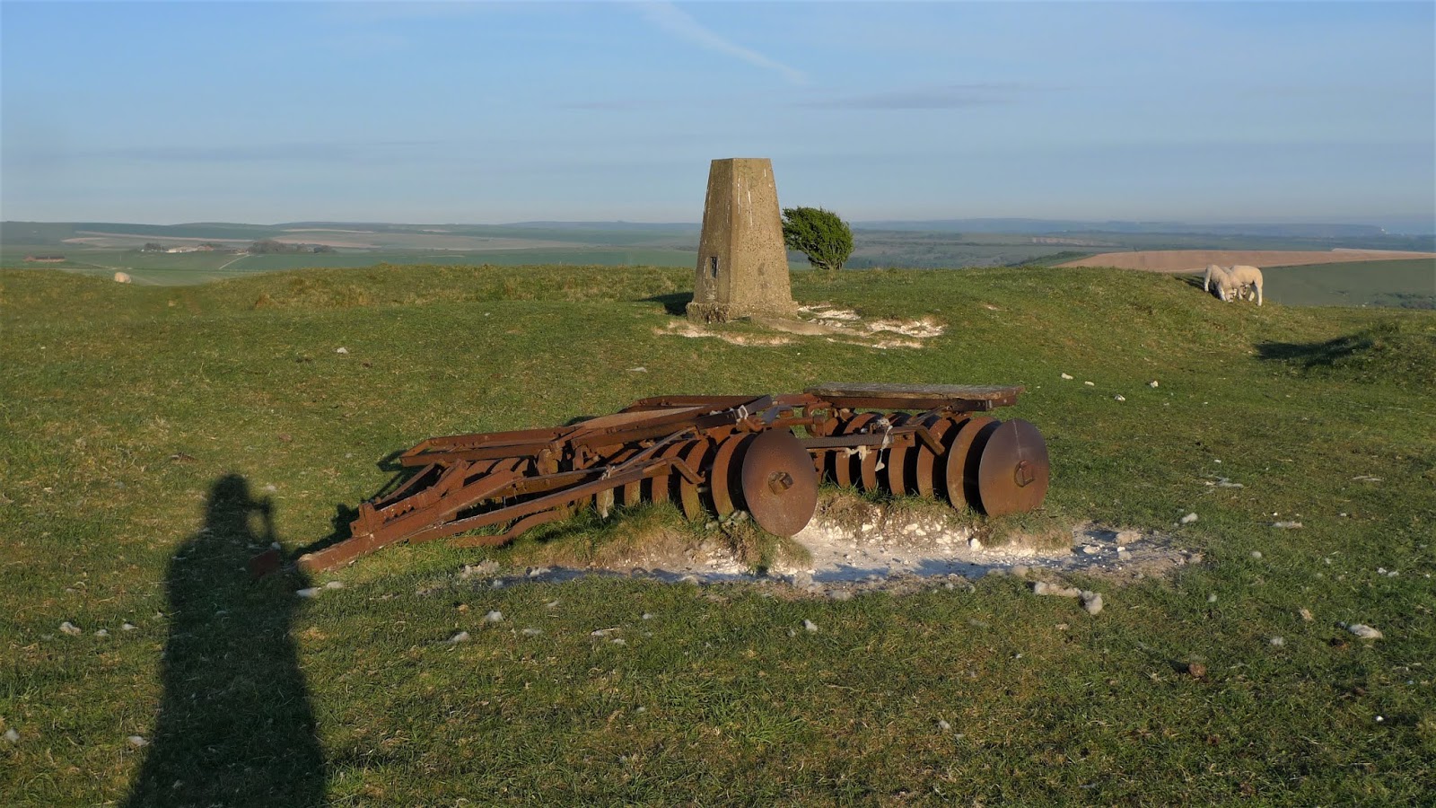


Concrete-and-steel trig points also look interesting in B&W:


I often wonder how they got these very solid and heavy pillars into position. Certainly not in a rucksack! Feasibly, they got a crane up here, but sometimes the pillar is in a high place so steep and craggy that no wheeled vehicle could possibly get near the spot. Or so you'd think. Done by helicopter? But then surely most were installed before heavy-lifting helicopters were a practical reality.
Although shown in blue on the map - implying water - the dew pond was in fact as dry as a bone.

Well, the way ahead looked inviting, and I still had ample time in hand. There was White Lion Pond to see, and - if I had time - the radio masts on Beddingham Hill.

There were pretty little lambs everywhere, never straying far from their mums, but nervously curious curious to know what I was and where I would go next.

I passed some isolated trees, even more notably windswept. These were festooned with strands of wool. Perhaps the sheep rubbed themselves on them.

Then a fence, with a gate in it. White Lion Pond was beyond, off downhill to the right, but made invisible by clumps of gorse. On a fence post, in fact rammed into the top of it, was a big lump of flint. It seemed to be head-shaped. One side had an 'eye'. It wasn't a human head. Ah, it was meant to be a 'white lion'!


Once you realised what it was meant to resemble, it was impressive. Only the back of the head had been chipped in any way; otherwise it was entirely natural.
Close by was a metal cage-like contraption that farmers use to interrogate their sheep with. The poor animal is forced inside, and then a kind of two-door gate is locked around their neck. The farmer can then probe the sheep with insinuating questions about its love life, or its political leanings, or whether it thinks Tesco or Sainsbury's is the better superstore. Maybe the sheep gets daubed with a paint mark too. How would I know? It made an interesting subject for the ever-eager little Leica though. I gave in, and let it take pictures to its heart's content.


It was now 7.30pm, and the sun was beginning to sink. I looked at the radio masts not so very far away.

Was it worth going there? No. What was so fascinating about radio masts anyway? But I did want to see White Lion Pond. Somewhere in that gorse just ahead, downhill to the right. I found a way in, and walked slowly forward. And there it was, not an ancient 'natural' pond this time. A more recent construction in concrete, though still decades old. And not dry - there was a small pool of water in the centre. And surely something taking a drink. I advanced very, very slowly.

If you enlarge the shot above, you can make it out. It was a fox.

I'd been detected. The fox was already quitting the pond, though in no hurry.

Only 'digital zoom' pictures, I'm afraid. And in not-very-good light. But you can clearly see Monsieur Reynard, coolly exiting stage left. I have to say, not a fat fox. It could do with a jolly good meal. By the time I reached the pond myself, it had vanished. I examined the paw and claw marks in the mud.


Lone Ranger: 'What do you see, Tonto?'
Faithful Indian companion Tonto: 'Recent paw marks, Kemo Sabe. A fox. With scar on its left ear. And hungry - no food for many moons.'
You can easily imagine it.
An artificial pond it might be, but there was something very restful about being here. It was secluded, and I don't suppose many SDW walkers ever detour to find the pond. No wonder the fox felt safe - until I turned up. I lingered, for a while lost in thought.

But the light was going. Time to retrace my steps. two miles back to where I'd left Fiona. I'd be lucky to get there in any kind of light at all.
Back past the windswept trees, now silhouetted against the setting sun.

Back past the ewes and their lambs, their fleeces orange in the fading light.

The Red Lion Pond and the trig point, defended by a brave little lamb.

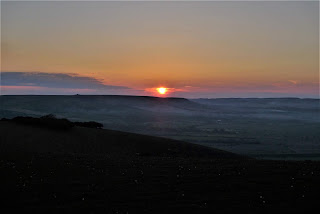
I stopped briefly to get a sunset shot or two, before the sun hit the horizon.


And still a mile to go. At least it was all downhill! As I sped on, I paused now and then to take the sun getting lower and redder.

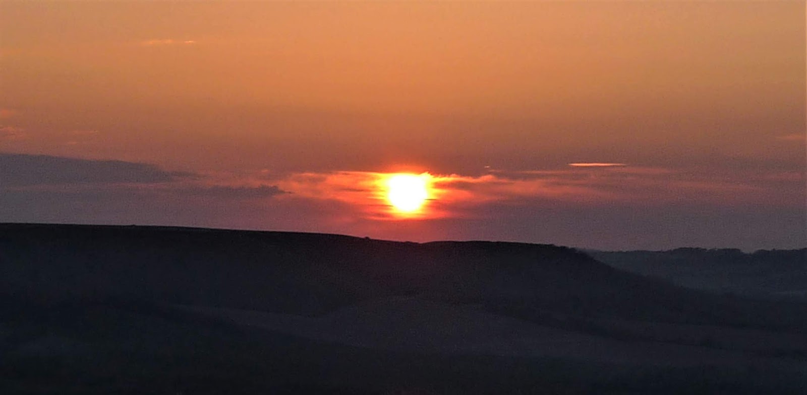

It wasn't quite as dark as this - I've exposed for the sun, and not the land. There was ample daylight to see by at ground level.
Back at Fiona, with the rear hatch open, I eased my boots off. The car nearby started up. Somebody else had come here for a walk. The person in the driving seat somehow looked familiar. She glanced at me. Mutual recognition. She reparked her car, and we had half and hour's conversation in the gathering dark, eight feet apart to maintain proper social distancing.
It was a lady named Gloria, whom I'd met a few evenings earlier, at close-by Southease station. She was passionate about photography too. We'd had a great conversation. And now an unexpected second encounter! How can such a thing happen? The curse of the lockdown is that we couldn't take this forward anytime soon. But she knows she can get my email address from this blog, and if she is exhibiting her prints in the months to come, she has the means to send me an invitation. And I would like to see her work. I'm always ready to study another photographer's technique.
I got home at 9.00pm. It was very dark by then. I checked my Fitbit. 15,000 steps.
Subscribe to:
Posts (Atom)
