Nor is it actually what the law says or provides. No mention of drones in the statute! Nor of other tactics the police have used. It's easy to see that this is a developing area, and that things like drones can be an attractive tool when the police can't be everywhere at once. But I won't be the first to suggest that leaping in with controversial methods isn't going to get the public solidly on the police's side. A more softy-softly way would have been better.
Anyway, it now looks as if all forces will be adopting a common approach, which will mean more pernickety policing in some parts, and more toned-down policing in others. Given that, I think it's proper for the public - myself included - to be sensible and reasonable where 'drive-to-walking' is concerned.
I'd say I was sensible and reasonable right now; but I'll be making it a personal rule henceforth, so that if an officer asks me where I live, it will be clear to him or her that I haven't driven far, and obvious that the purpose of my short journey is to take a nice walk somewhere different, at a time (late afternoon or early evening) when I can reasonably expect to meet very few people. And that I know what the social distancing requirement is, and will always apply it.
In any case, I'm rationing my 'drive-to-walk' outings. If - let's say - it's fine to drive to any spot within a ten-mile radius, then I have (applying the formula for the internal area of a circle, πr²) no less than 314 square miles to play with. With a fifteen-mile radius it's 707 square miles. Of course I can't reach every spot by car; but even so, that's more than enough area for an outing that shouldn't last more than a couple of hours anyway. And I'm doing this only every other evening. In between, it's a very local walk from the front door of Melford Hall.
So where have I been? Well, here are three typical and recent destinations that I enjoyed, all visited late in the day on sunny evenings. I rather think the middle one might now be considered just slightly too far from home, although I don't think I would have serious qualms about a revisit.
First up, Barcombe Mills, a bit north of Lewes. Here's a map.

I parked Fiona on the side of the road near the left-hand edge of the map (ignore the blue pin), then walked on the marked long-distance footpath (it's the Sussex Ouse Valley Way) to the footbridge across the Ouse, at the top right of the map, a bit short of Lower Barn Cottage; then retraced my steps. That way I got a succession of sunlit river scenes on the outward leg, and the best of the sunset on the way back. I encountered one couple sitting on a bench, and two other couples walking their dogs. We carefully observed social distancing.
And these were some of the views.


At one time, the Ouse was navigable for barges.


I love reflections!


I'd now reached the bridge where I was going to turn back. It was a river-bridge worthy of a game of Pooh-sticks at another time.


This was all a flood-plain, of course. But the flat land to the east still looked lovely in the mellowing sunlight. There was a curious cloud-formation, too.


Near to where I started, the placid water was getting dark and mysterious as the sun sank.

Barcombe Mills has one of those World War Two pillboxes - machine-gun posts that guarded coastal landing-beaches, road bends and river crossings, often right out in the middle of nowhere. They were mostly built in 1940 and 1941. There are still thousands about, generally hard to spot. This one had had its entrance bricked up, and was somewhat overgrown (their usual state nowadays)


Next, Isfield. Another day. Another map.

My objective this time was the church, situated at the end of a narrow lane away from the modern village. People shifted to be near to the railway station, on the line between Uckfield and Lewes. That section of line closed in 1969, fifty-one years ago, but a mile-long stretch has for many years been preserved as a heritage railway known as the Lavender Line. The volunteers behind that have made a great job with the station itself, although clearly they haven't got the resources of the Bluebell Line not far off. Coming up from Lewes, I stopped off to look at Isfield station.


It looked like a nice place for tea and cake sometime.
Now for the church. On the way, I saw this arresting village sign.

It was in iron, and clearly shows the river, the church, a steam locomotive, the South Downs in the distance, and, at the top, a curious grinning fish wearing a crown. What's that about? Well, the pub near the station - presently shut, of course - was called The Laughing Fish. So there must be some local legend that involves a fish, presumably with a tie-up to Royalty. That's as far I can can guess. I must try to discover more, but a quick Google search hasn't enlightened me yet.
The narrow lane to the church led me into a meadow fringed with waterways, for this is close to where the River Uck meets the River Ouse. Ah, those earthy Sussex names! North of the confluence, close to the church, was once a Norman motte-and-bailey castle. It overlooked the old Roman road that crossed the Ouse here by a ford. A damp spot to build a castle, methinks.
Photographically, the church came well up to expectations, assisted by that tall adjacent tree:

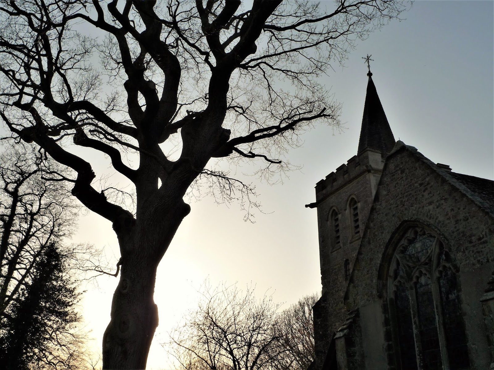

The church was of course locked. Nice shadows on the tower, though. And next to the porch, a camellia bush in bloom.

Tucked away near the river was another of those pillboxes. It was difficult to see from a hundred yards, and only the very curious would approach.


It wasn't bricked up. It looked in a pretty good state. I peered inside.

Surely that 'A238' painted on the interior wall couldn't be original? But I forced to believe it was. The interior wasn't free of leaf litter, but was still remarkably unblemished by time. Surely it had been cleaned out more than once in the last eighty-odd years? (Although why?) I explored.


There was no smell of urine or mould; no discarded plastic bottles, nor beer cans. No spent shotgun cartridges either. No rubbish of any kind. You could install a squad of machine-gunners in here straight away, without any preparation, ready to repel the enemy to the last man, no problem. I pointed two fingers at the doorway, ready for trouble.

All I would say, is that anyone spending a winter night in there would be frozen and miserable by dawn. It would be a cheerless assignment, manning such a spartan outpost. But in 1940, with the threat of a German invasion, these pillboxes could be quickly built, and might have slowed the advance of the Wehrmacht for a few hours. They would buy time.
By now I really ought to go home. So far I hadn't encountered any other walker. And that's really the point of seeking out these deserted and little-known places.
As I drove back to the westbound A272, I passed through Piltdown. Yet another map.

And another village sign.

This one was also in iron, but more graceful. It showed a golfer (there's a big course here); a stylised tree and two swans (there's a lake); and a rather strange humanoid skull.
The latter is a reference to the infamous Piltdown Man, who for a long while was regarded as the Missing Link between apes and modern man. Bits of him were unearthed locally in 1912, pieced together, and duly hailed as magnificent proof that the Missing Link had naturally been an Englishman. The whole sorry tale is told here: https://en.wikipedia.org/wiki/Piltdown_Man. It was a scientific fraud that took 41 years to expose, and the persons responsible have never been satisfactorily identified. But it's a good story, and the thing that put Piltdown on the map.
When the coronavirus pandemic has run its course, and pubs are open again, there's a local hostelry called The Piltdown Man to visit. It was originally called The Lamb, then (to attract the tourist) renamed itself The Piltdown Man, and this was its name for many decades. In the last ten years it reinvented itself as a gastro-pub, becoming The Lamb at Piltdown. Now it's back to being The Piltdown Man once more.
I mentioned a lake, the one shown on the map. I'd already had my 'official' exercise walk, back at Isfield, but I couldn't resist doing a circuit of the lake, to shoot the setting sun on the water. It was a solitary stroll, with only Brent geese honking occasionally on the golf course. But I got my shots. The 'Pond closed' notice refers to angling, not walking.


At one point, I pointed the little Leica to the ground. Had I just seen a cranium sticking out? Or was it a jawbone? And was that a tooth?

Tsk. The light just wasn't quite good enough to be certain. And I don't think I'll be able to find the same spot if I return.
Hey ho.


